By David Berger
The journey across Russia had stretched into a five week odyssey of eastings, always eastings. Our purpose, the reason we had been born and the sole reason we now apparently existed, was to keep making progress eastwards.
Nothing filled our days but the thought of the next five hundred nautical mile leg eastwards across the rolling brown and green taiga, a wilderness of larch trees and swamp stretching to infinity. Getting to Japan had changed all that and now, in Kagoshima on the island of Kyushu, at the far southern tip of the Japanese home islands, we stood poised to run almost due south through the Philippines and Indonesia to our own part-time home on the north-west coast of the Australian continent, Broome. It felt like we had peddled to the top of a steep hill and were now looking at the just rewards of our labour: a leisurely, downhill freewheel home.
The Bazflyers, Barry and Sandra Payne, with the enviable cruising speed of their Comanche and their extra long range, headed off non-stop to Clark Field in the Philippines, but that was too far for us. Even with a stop in Okinawa, 350nm to the south down the chain of the Ryukyu Islands, we would be making our longest hop of the trip to get to the Philippines: over eight hundred nautical miles from Okinawa to Clark Field.
But there was another reason to stop in Okinawa, a reason which transcended the mundane limitations of pure geography. During the several weeks that Tom had been helping to get the aircraft ready in the avionics shop in Grand Junction, he had become addicted to Taco Bell, and it was an addiction I had quickly come to share. I’m not proud of this, of course I’m not, but equally I’m not making any apologies. We had come to a point where, if it was available, we needed Taco Bell, and Google maps was showing three Taco Bell outlets on the island. Why there might be three Taco Bells on the tiny island of Okinawa, adrift in the East China Sea, we did not think to question. This was Japan, after all, land of the fetish for all things foreign, especially American.
By the time Barry and Sandra left, I was starting to feel better from my stomach bug and the building of another cyclone in the north Pacific was a signal for us to get our skates on. The next day, we thanked Paolo for his help and kindness and launched on the short three hundred and fifty nautical mile leg to the international airport at Naha on Okinawa.
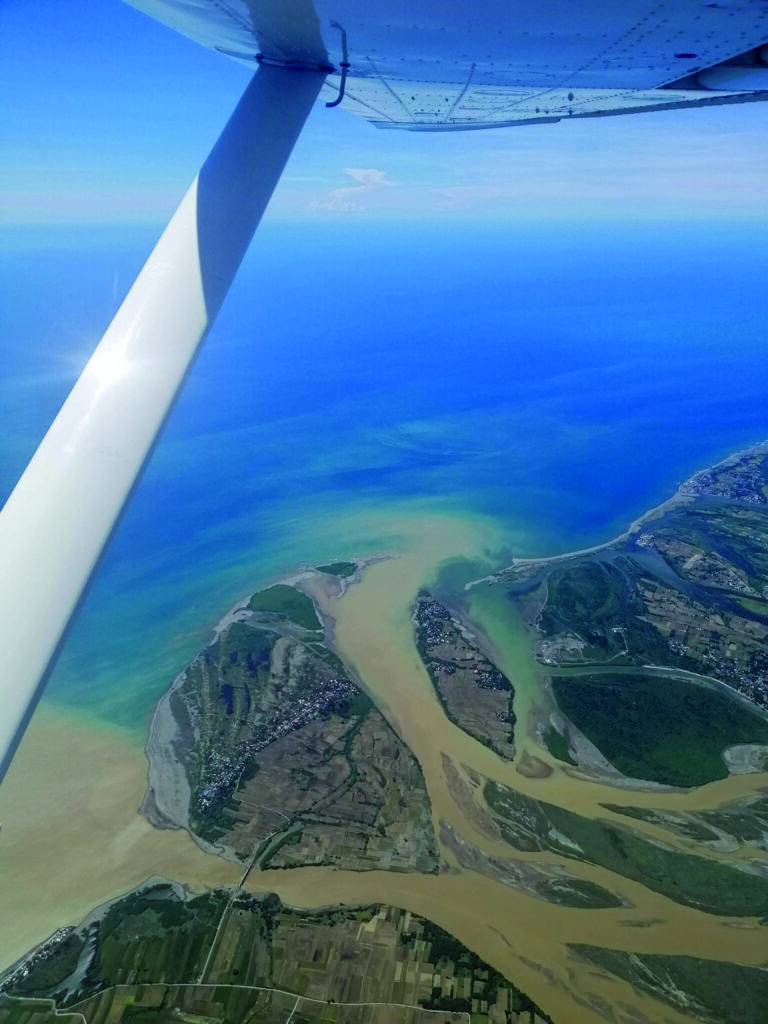
It was a blissful flight down the long chain of the Ryukyus. Island hopping heaps psychological comfort on the pilot of a single engine piston aircraft, where long open water crossings far from land require constant self-soothing, reassurance and rationalisation. Even then, the fear simmers just below the surface, denied and suppressed, but bubbling up at the tiniest imaginary hint of a miss in the engine.
One after another, the tiny islands provided a picture of bucolic contentment in the early morning from six thousand feet. Mostly divided into the tiny fields so typical of Japan, they each had one or two small, geometrically organised villages. Had the atomic bombs not been dropped, resulting in Japan’s capitulation in WWII, these tranquil islands would have been stepping stones on the route north for the American forces. As it was, they narrowly escaped the near total annihilation that Okinawa experienced.
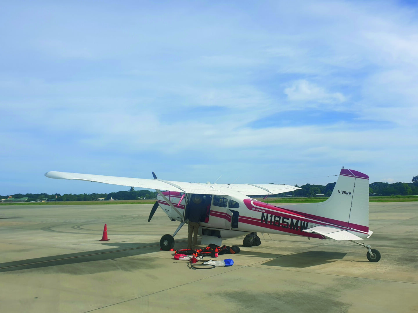
Our route brought us down the west side of Okinawa, the northern end of which looked surprisingly forested and underpopulated for a small island with one and a half million inhabitants and a plethora of American military bases, and we were soon landing at the joint civil and military airport at Naha. We were directed to the small GA parking area in the wilds of the western side of the airport and pulled up next to a Japaneseregistered Bonanza, which seems to be based in Okinawa. Evidently, it is worth the hassle and expense for one person, at least, to fly privately in Japan. We were soon refuelled and then whisked over to the terminal in a little van driven by an immaculately coiffed, tiny lady (you have to get something for your US$2500 fee, after all). There, we rented a car and headed north out of the congested city, tummies rumbling, to the first Taco Bell programmed into Google maps.
Expectations were high, but our jubilant spirit was soon dashed by the presence of a tall wire fence with a sign which read ‘Camp Foster’ blocking the way between us and satiation at the familiar purple sign, visible not fifty yards away. We parked the car and walked up to the kiosk by the gate, addressing ourselves by intercom to a supremely disinterested American servicewoman through the bul- let proof glass: “What is your business on the base, Sir?”
“Er, we’d like to go to Taco Bell, please. We’ve flown two-thirds of the way across the world and we’re really craving a Taco Bell!” We smiled and tried to be as ap- pealing as we could.
“I’m sorry, Sir, only people with official business are allowed on the base.”
Of course, it was the same story at the next Taco Bell, which also jeered at us from behind the wire, this time at Camp Kadena, the huge US Marines air base. We knew now why Okinawa was home to three Taco Bell outlets, all of which were destined to remain forever off limits to us.
We consoled ourselves with our standard self-soother when faced with disappointments on the trip – “At least the engine didn’t fail yesterday!” – and continued north along the coast. We visited the aquarium (really big fish with frogman attendants bobbing around for no readily apparent reason) and finally came to our resting place for the night, the Yanbaru Hostel, a remarkably avant garde design hotel in the small seaside town of Kunigami.
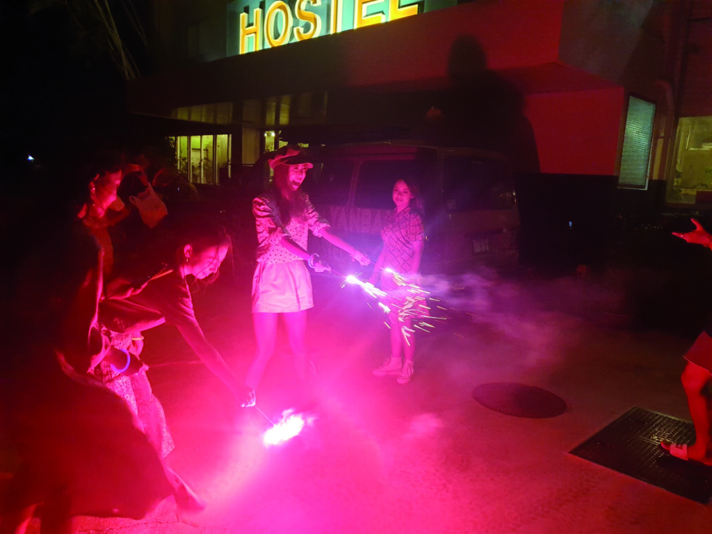
Settled into our stylish room and feeling very avant garde ourselves, we con- gratulated ourselves on this remarkable find and went for dinner at the less than reassuringly named ‘Wild Cat Restaurant’ (山ねこ料理店), a tiny kiosk of a place just round the corner, run by a fellow and his smiley mum. He did the cooking, she did the front of house and, filled with laughter, chatter and wreaths of cigarette smoke, it had the appealing atmosphere of a Central European kneipe of the 1930s. “More than satisfactory,” we said as, with full bellies, we returned to the hotel. By now, it was about 10pm and we were greeted in the courtyard by a curious sight. Half a dozen highly made up young women were tottering round on high heels, giggling consistently, if rather forcedly, and waving sparklers in the air, while being photographed by a young man.
These, it turned out, were Instagram in- fluencers on a photo shoot, mostly from the island of Ishigaki, about two hun- dred nautical miles to the southwest and Japan’s tropical holiday isle, sitting as it does immediately north of the Tropic of Cancer. The man was their friend (I pre- sume through Instagram), a young veteri- nary student from cold, snowy Hokkaido, taking a year out to cavort with tropical lovelies. And who, frankly, could blame him? Tom was a great hit with the as- semblage and was soon featuring in all the photos, a big cheesy grin on his face.
The next day, we drove the two hours back to Naha and put up in an anonymous hotel not far from the airport. The winds looked favourable for the following day; an important consideration given the length of the leg.
Tortuous IFR vectoring due west after takeoff added about thirty nautical miles to the journey, but we were soon on course, making 125 to 130 knots ground speed, at the low altitude of 3000ft to catch the favourable winds. Before long we were handed off by Fukuoka Control to the oceanic controller on HF, which turned out to be… San Francisco Radio. The faint American voice coming and going through the ether was, however, rather intermittent and served more to lend a thrill of the exotic to the flight than any useful position reporting function.
Apart from a few hundred miles in the middle, we were never all that far from land and there was a prodigious amount of shipping, which I enjoyed listening to on the marine VHF we have mounted in the panel. The warm, tropical water below made this feel much less unpleasant than crossing the cold North Atlantic and it seemed a very short time before we were passing just to the south of the Philippine-owned Batanes Islands, which sit in the middle of the Luzon Strait between the Philippine island of Luzon and the southern tip of Taiwan.
At no time did our fuel at destination show as less than 35 gallons, or three hours’ endurance, on this 840 nautical mile leg. A later model Cessna 185 with 30 gallon tip tanks and 114 gallons total usable fuel is a phenomenally versatile machine. Running lean of peak at about 2200 RPM and 20-23” of manifold pressure (depending on altitude), you can expect a fuel burn of around 11.5 GPH and a true airspeed of about 122 knots, rising to 128 knots as you lighten up, giving you a still air range of about 1150 nautical miles, accounting for fuel used in the climb. Our machine has the larger 8.50 wheels, an Aerocet belly pod and an aftermarket 14” tailwheel, and it still does all that with an after fuel useful load of over 370kg. That’s the legal useful load, of course. Ask any 185 cowboy what load the aircraft will really fly with (but make sure to mind that CofG – it’s easy to load it too far aft!). At the same time, you can operate it with a load out of the tiniest and sketchiest of backcountry strips in the Landsborough Valley and Fiordland, as we would go on to do just before the pandemic hit in early 2020.
The IFR route took us to the northwest tip of Luzon then due south along the coast to Clark International Airport at the city of Angeles, not far north of Manila. This kept us to the west of the impos- ing and mostly cloud-covered Cordillera Central mountain range, which runs north-south for over 350km in this part of northern Luzon and reaches its highest point at nearly ten thousand feet.
Looking down on the Philippines, it was immediately apparent that this was a poor and crowded country. We had reached South East Asia proper.
Clark Field, as everyone calls it, harking back to its days as a US airbase, soon came into view, and our roughly US$2500 landing and handling fee was soon being spent in the form of a few sleepy officials coming to cast a disinterested eye over our paperwork before wandering off once more whence they had come.
If one ‘Aviation Monetary Unit’ is gen- erally reckoned to be US$1000 in the Western world, then it is at least US$5000 in Asia. I’m afraid that’s the exchange rate, folks. I don’t recommend flying for fun in Asia.
And so we had arrived, reeling from the fact that our faithful little aircraft had once
more transported us through what felt like a wormhole in space. Slowly but surely we were eating up the earth’s surface and would soon run out of earth to fly around. The realisation that the earth isn’t actually all that large is striking and sobering.
The next day was a short leg of 350nm to Puerto Princesa on the island of Palawan, a stop that Barry and Sandra had again managed to omit because of their prodigious range, enabled by a rath- er complex affair of eight or so fuel tanks. Such a system is something I trust them to operate without a moment’s hesitation. Myself? Less so.
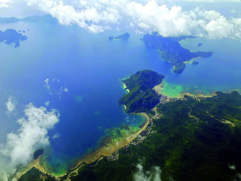
It was a stunning flight over a tropical ocean and then down the forested spine of the island of Palawan. The knowledge that the southern Philippines, and espe- cially parts of Palawan and the islands of the Sulu Sea, were the haunt of pirates and Islamic guerrillas lent the already ex- otic experience an extra frisson. We were in tiger country alright.
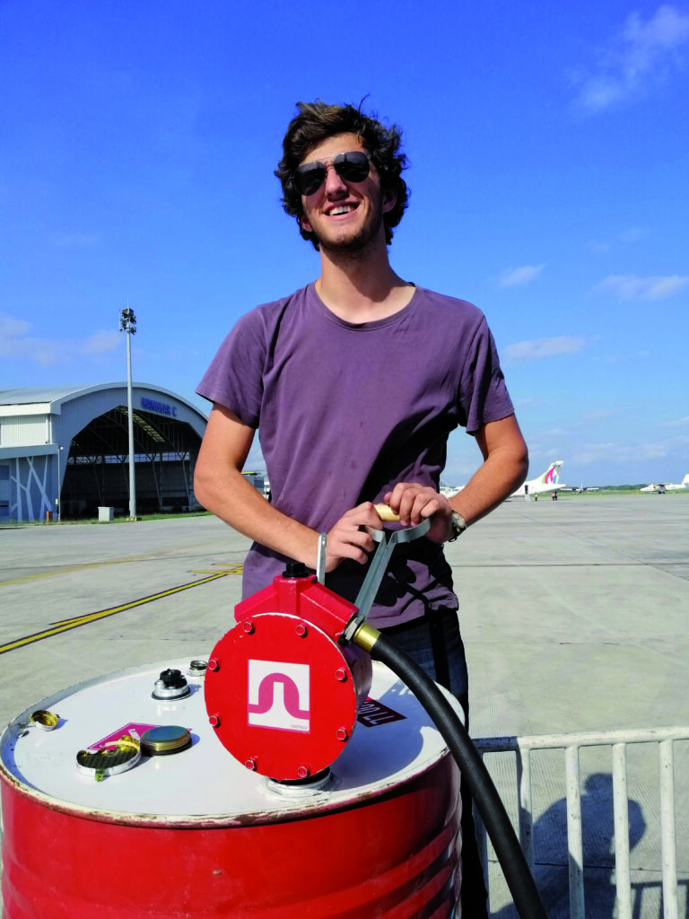
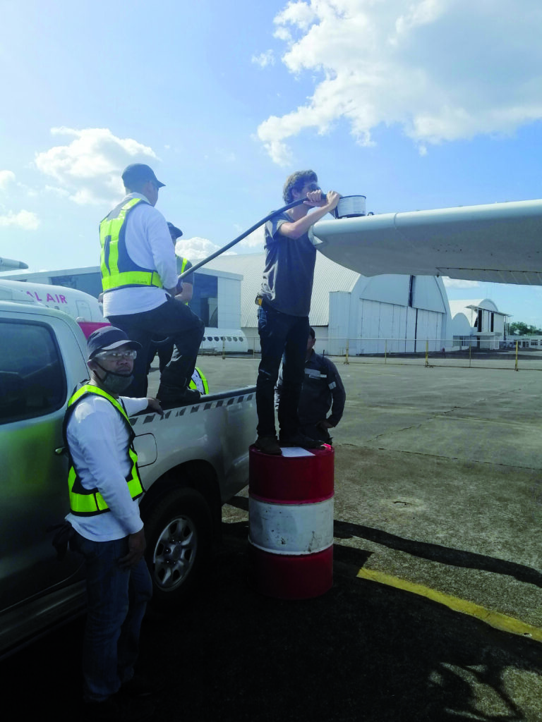
Everything went smoothly at Puerto Princesa airport and a pristine drum of avgas turned up on cue, which Tom hand-pumped before we were driven into town. This had much more the teeming feel of Asia than had Angeles City and, even though the airport itself sits plonk in the middle of town, it took ages to drive the short distance to the posh hotel where the expats stay. My imagination ran overtime. It felt like the kind of place that Islamic terrorists would storm and hold everyone hostage, but of course we had a very pleasant and uneventful stay and wandered the local streets, reveling in the tropical warmth and humidity, and in just at being in Asia.
There had been some kerfuffle over the fact that our course took us briefly into Malaysian airspace over Sabah, but the excellent Mike Gray of White Rose Aviation was sorting all our permits by this time and it had been resolved shortly before we were due to take off.
We departed to the east over the ocean following a Cebu Pacific Airbus, climbed straight to 10,000ft and set course to the south-southwest over the sinister-sound- ing (and sinister in reality) Sulu Sea.
It was calm up high over the sea, as it generally is. We passed the time peering down at the smattering of islands and the few tiny craft making their way between them, speculating as to what fearsome characters might inhabit them and just what a bonanza we would present if our trusty Continental were finally to give up the ghost and we should fall into their laps. Aye, there would be feasting and jubilation aplenty!
I tried to come up with a plan against this eventuality, but failed. Tom’s solution was just to switch off the engine instruments screen on the G500TXi and listen to his playlist on Spotify. Sometimes, denial really is the best strategy.
Like almost everyone, I suspect, I underestimated Borneo. It sits there, a large blob in the middle of the map of South- East Asia, and you tend to ignore it, but it’s big. Really big. It’s the third largest island in the world after Greenland and New Guinea. You didn’t know that either, did you? Well, we were now finding out. The leg from Puerto Princesa to Balikpapan, far down on the southeast coast, was over 650nm. We started flying past Borneo then just kept flying.
The morning wore on as we trundled along and the usual equatorial cumulus began to build up over the land to our right. Ahead of us lay a finger of a peninsula jutting out into the Makassar Strait. The cumulus was building on that too, and we had to cross it. It was about 50nm wide. A diversion around the eastern tip, which would keep us over the ocean and thus free of cloud, would add about 75nm to the trip. I wanted to divert, Tom didn’t. He thought we could get across before the clouds got too high. We pressed on.
Dear reader, the clouds bubbled up around our ears like bubblebath under a gushing tap. We climbed then climbed some more. We took ever more eccentric diversions around ever more towering pillars. We kept saying things like “not long now” and “they can’t get much higher” and eventually, with a sigh of relief, we had squeaked through and were once more over the coast and cloud-free.
Our attention was soon diverted by the sad sight of the extensive palm oil plantations in areas of cleared rainfor- est in this part of the country, and before long we were starting our descent into Balikpapan, another leg ticked off.
Australia was so close we could almost smell it.
This article first appeared in the Summer 2022 edition of Approach Magazine, the dedicated magazine of AOPA NZ, which is published quarterly.